
Nautical charts
The coordinate system The coordinate system is used to indicate positions on Earth. We do this by representing latitude and longitude. The equator divides the… Read More »Nautical charts
![]()
![]()
![]()
![]()
In this free online coastal navigation course you can learn how to navigate along coastal waters. The examples are for NW Europe but the same principles count all over the world. At the bottom of the articles you will find multiple choice questions to test your knowledge. You only need to buy nautical chart 1630, a course plotter and dividers.
The coordinate system The coordinate system is used to indicate positions on Earth. We do this by representing latitude and longitude. The equator divides the… Read More »Nautical charts

The compass There are different north directions. Compass north is where the compass points. Magnetic north is where the compass would point if it were… Read More »From compass course to course over ground

Measuring a position Take the compass and measure the distance from the object to a parallel and read the latiude at the vertical side of… Read More »Chartwork

Cross bearing We can determine our estmated position by means of a cross-bearing. We make a compass bearing of a point that we can recognize… Read More »Compass Bearings
The attraction of the sun and moon creates the tides. It is often thought that the tides are created by just the attraction of the… Read More »Tidal calculations
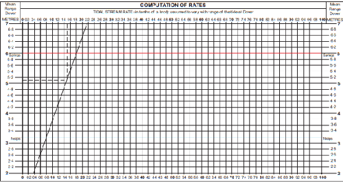
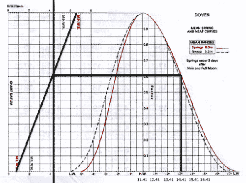
Secondary port tidal prediction form If a particular port is a secondary port and we want to calculate the rise at a particular time, we… Read More »Secondary ports and Computation of rates

In the Netherlands, we have two buoyage systems: the SIGNI system on inland waterways and the IALA-A system at sea. Let’s start with the SIGNI… Read More »Buoyage

AIS AIS stands for (Automatic Indentification System). An AIS broadcasts information about the ship every few seconds, including name, identification number, position, course, speed and… Read More »Electronic navigation equipment

What is Radar? Radar is an electronic navigation aid that allows us to determine the distance and direction to coastlines, buoys and ships. The radio… Read More »Radar on board

Wind The weather and especially the wind have a major impact on the safety. Wind is air flowing from a high-pressure area to a low-pressure… Read More »Meteorology

This lesson discusses the routing form. Download the routing form Global planning of multi-day sea voyage If we are going to sail for several weeks,… Read More »Routing

Every sailor knows that communication equipment on board can be vital and Maritime communication is an essential part of offshore sailing. Global Maritime Distress and… Read More »GMDSS

A ship’s manoeuvring characteristics are determined by a number of factors, as described below. Factors of ship maneuverability Weight Of course, the weight of the… Read More »Manoeuvring and docking

Definitions Let’s start this lesson with the following definitions:Sea: created by the wind at that moment.Swell: created by the wind that was blowing earlier.Waves =… Read More »Waves